


B.C.’s latest Snow Conditions and Water Supply Bulletin show lower than normal snowpack levels province-wide.
The current snowpack levels as of March 1st sit at around 73 per cent, while in January, the levels hovered around 87 per cent. Closer to normal, but B.C. forecasters say it was one of the driest winters recently.
Jonathan Boyd, a Hydrologist for the River Forecast Centre, says the drier January and February have driven the levels to below average across the province.
“January is usually the month where we get the greatest amount of snow accumulations,” Boyd says. “The big shift happened when the provincial average switched from 87 per cent to 72 per cent on February 1. Which is one of the greatest drops I have seen from a month-to-month basis.”
He says, while the provincial average is lower, it is not as low as this time last year, which hit an average low of 66 per cent. However, there is a “possibility” of a drought in the Chilcotin region. Which has the lowest normal percentage at 16 per cent.
“The possibility is there, certainly anytime we’re below normal averages,” Boyd says. “What we are seeing, at least for March, is a little bit more snow has been added because of snow storms so far for this first half of the month. So it is unlikely that we will be as low as last year, which is a positive. The big question, of course, remains around what happens in the summer.”
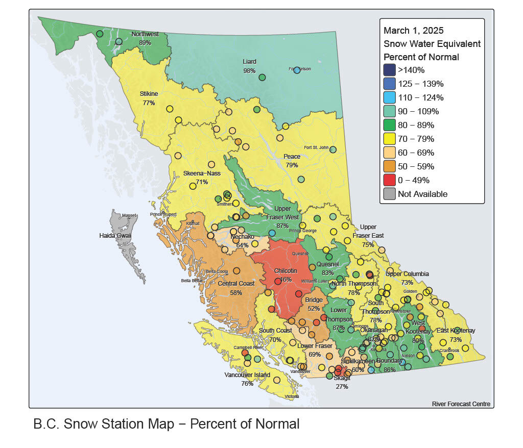
The Quesnel region is sitting at around 83 per cent as of March 1. While it is down from February’s average of 87 per cent, Boyd says the Quesnel region is in the “most ideal situation” for lower hazards.
Boyd says the worst-case scenario would be a drought as early as April, that means the Chilcotin could be at risk for flash floods, with a fast melting season.
The B.C. River Forecast Centre releases updated bulletin on a month-to-month basis up until May. Boyd says while they are accurate, it is hard to predict weather patterns further than a 14-day period. Boyd says that as of right now, things look positive through the month of March.
“The most ideal situation all the way around is to have cooler conditions right through May and June. For the time being, it still looks like generally cooler seasonal temperatures with some more precipitation events rolling through. We want to get that last bump of mountain snow before the melt season happens.”
Something going on in the Cariboo you think people should know about?
Send us a news tip by emailing [email protected].


